Sunday, August 30, 2009

Cedar Break & Bryce Canyon

Sunday, August 30, 2009
(high 97, low 66, sunny)

Yesterday was a travel day, we left Green River and came south to Cedar City, UT. We needed to see a little city again, it'd been over a week. There is a cloud south of us, I believe it's a forest fire that's been controlled and is burning itself out. I can smell a little smoke during the night.

Last night we had a wonderful dinner at Milt's Steak & Seaford on Rt 14 going out of Cedar City. It was delicious, although a little pricey for us. It was our half-way-thru-our-trip dinner.

This morning we rode up Route 14 again. Along the way we could see more interesting mountains and rock formations.

We stopped at Cedar Break National Monument, a smaller version of Bryce Canyon, and it felt great. The temperature was about 68 and very breezy. For once we weren't sweating. The air was thin, however, and I'm having a little trouble with shortness of breath when I do anything. There is 20% less oxygen up here. It's a little hard to see, but there are stone spires, columns, arches, pinnacles, and intricate canyons in varying shades of red, yellow and purple.

It was kinda strange, but on top of that mountain, farther down the road, were many meadows. We found some lava-flow formations and picked up a couple pieces to bring home.


At Bryce Canyon we drove to the end of the road, Rainbow Point. It was the best place for pictures.

On the way back down, there were other vista points including one for the Natural Bridge which is really not a bridge but an arch.


Back down from the canyon, we stopped for supper. There was a row of little shops. In the parking lot was the vehicle of the day, a sleeper bus. We saw the same vehicle in Salt Lake but couldn't get a picture. Per the internet, it appears to be a Red Rotel Tour Bus.

On the way home, we could see the smoke cloud from the fire. The sun was behind it and was bright red. The picture didn't capture the color correctly but you can see the smoke cloud in these pictures. On the news, it said the fire was in New Harmony, 22 miles from us, and may be out of control. Three homes have burned, 75 people have been evacuated.

Friday, August 28, 2009

Canyonland

Friday, August 28, 2009
(high 96, low 56, bright sun)

We stayed an extra day in Green River to revisit the Canyonlands National Park, going to the southern entrance to see the Needles. This is open range country. There are wire fences between the large ranches that need to cross the roads. Since the fence cannot cross the road, there are metal grate-like areas in the road that serve the same purpose. The cattle will not cross the grate. The roadway was lined with miles of small sunflowers and these pretty purple ones. There were occasional corrals which are used during cattle roundup time. Modern cowboys use helicopters to round up the cattle.


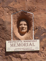
South of Moab we spotted a large rock formation that said Hole in the Rock. We discovered that a man and his wife, Albert and Gladys Christiansen, carved a home inside the rock. Photos of the inside were not allowed so I can’t show you the wonderful place they made for themselves. They lived in it until their deaths, he in 1957, she in 1974. In the 1960’s electricity came to the Moab area and Mrs. Christiansen had the home wired.

The yard around the rock home was interestingly done in a playful manner. This section includes the “interesting car of the day”. The last two pictures are of their gravesite. I love coming upon these unexpected places.


We came upon a site called Newspaper Rock. Very interesting.


The road wound around the high dessert between huge rock formations and more arches.


A big surprise was a small lake/pond. Water is very scarce out here.


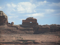
One of the rock formations I named Hohenzollern. It reminds me so much like the Hohenzollern castle sitting on a mountain in southern Germany.


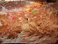
This is the visitor center in the park. I have used a picture of theirs to show you the layout of Canyonland. The red arrow points to the Colorado River, the green to the Green River. They meet at the yellow arrow, a point called the Confluence. The black arrows show the roads in the park. The raised part in the top left is the Needles and in the top right, the Maze. The Maze is an area of winding canyons used as the hideout for Butch Cassidy and his gang. The lawmen would get lost in there so would not pursue the gang..


We took a small hike to a roadside ruin of an Ancestrayl Puebloan granary. I was lucky enough to capture a picture of an old Puebloan sitting under a rock. He is well preserved for his age, don’tcha think?


This next arch is called the Wooden Shoe.


We saw some cacti in bloom.


We didn’t really see the Needles as we expected to but we did see some lovely additional rock formations.


We came to the southern side of the confluence and I walked out a ways but it involved some climbing that I didn’t feel comfortable doing, I knew I’d have to come back up. With the thin air, 95 degree temperature and my poor diseased heart, I settled for these pictures of the Green River bed. I don’t know if there is any water down there or not.


We drove south to Monticello, had pizza (it WAS Friday nite, ya know!), and Fred decided to continue along I 191 westward back up to Green River. It was a very long ride, especially in the canyons when it was getting dark. Every turn yielded another canyon, no other cars, and more canyons. Finally we got out of them and were riding along when we spotted a young couple with a flat tire, 26 miles south of Hanksville. We stopped to help them. They were a German couple from Stuttgart in the country for three days coming from the Grand Canyon. They were so grateful for our help. No one else had stopped. So within 15 minutes, they were on their way. The fellow was definitley not familiar with our American “donut” spare tires. Fred said that we were meant to take the long way home so we could be available to help them!